OUR RESEARCH
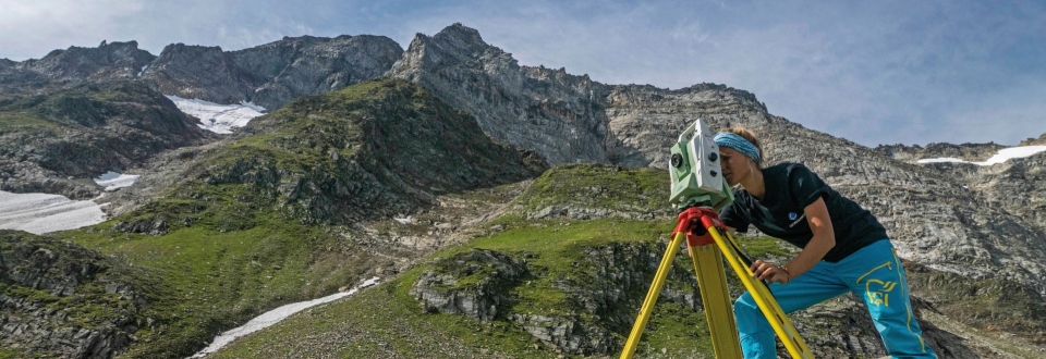
Alpine regions are known for their sensitivity to environmental changes, making them a critical area of study. Risks and opportunities resulting from these changes are at the forefront of our research which focuses on natural hazards, glacier retreat, permafrost degradation and risk analysis. Surface and subsurface conditions can exhibit considerable lag times in response to climatic changes. Thus, long-term monitoring is essential to accurately identify the consequences of recent warming and calibrate predictive models of future change. To facilitate data-based adaptation measures, we employ innovative satellite and UAV technologies, as well as geotechnical and geophysical methods.
Project MELT.AI

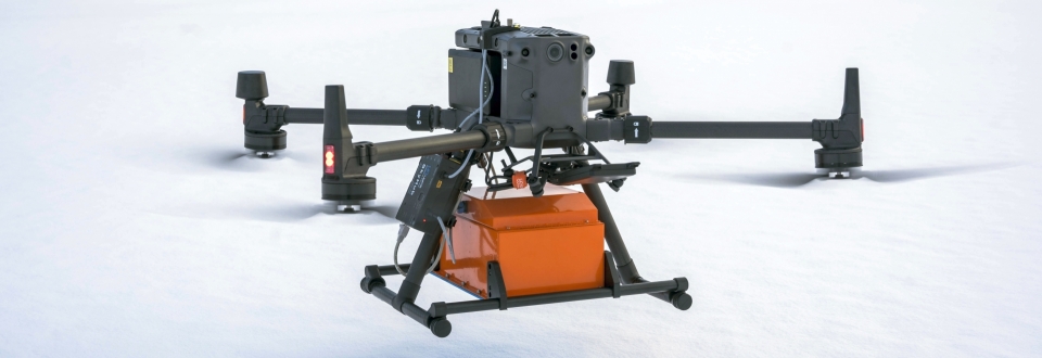
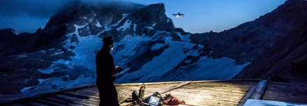
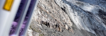
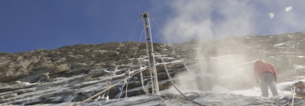
Conventional ground-based methods for measuring glacier thickness are extremely time-consuming and require demanding alpine efforts. As part of the FFG-funded project MELT.AI, we use UAV-based ground-penetrating radar surveys combined with AI-supported pattern recognition to rapidly and comprehensively map glacier thickness. This approach makes a significant contribution to improving our quantitative understanding of current glacier retreat and the remaining "lifespan" of our glaciers.
more details ...
PROJECT FROST.INI

As part of the EU project FROST.INI (Interreg VI-A Italy-Austria, 2021-2027), we are studying the effects of ongoing permafrost degradation in the summit regions of the Austrian-Italian Alps. The project aims to develop practical guidelines and solutions for operators of high-altitude infrastructure. FROST.INI brings together project partners from science, industry, and public administration, promotes cross-border cooperation activities, and contributes to enhanced resilience to the impacts of climate change.
more details ...
PROJECT UAV Glacier Monitoring Salzburg

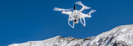
Since 2016, we have been systematically monitoring selected glaciers in the Hohe Tauern Range (Salzburg) using UAV-based remote sensing. The combination of UAV laser scanning, photogrammetry, and ground-penetrating radar enables the precise assessment of glacier surface geometry, ice thickness, and subglacial topography. This allows changes in ice volume and water equivalents to be quantified over multiple years and documented in robust time series – providing an important basis for analysing climate-driven developments as well as hydrological and natural hazard-related processes.
more details ...
PROJECT Climatic Sensitivity of high-alpine Cirques
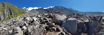
In high-alpine cirques, climate change-induced permafrost degradation and an increase in liquid precipitation are projected to promote the availability of fresh, unconsolidated sediments. The relevance of cirques as source areas of hazardous mass movements, such as debris flows, is therefore expected to grow significantly. The aim of the project is to better understand and accurately assess thermal subsurface conditions, mass movement activity, and future natural hazard potential under changing climatic conditions through continuous long-term monitoring of atmospheric, surface, and subsurface conditions.
more details ...
PROJECT HydroSAR

Our team at GEORESEARCH is proud to announce the launch of our newest project, HydroSAR. Together with our partners from the Government of Salzburg, Salzburg AG and the Technical University of Graz, we are working to assess the impacts of climate change on groundwater variability. HydroSAR aims to do just that by utilizing the power of satellite-based radar interferometry (InSAR) to measure groundwater-induced uplift/subsidence with millimeter accuracy.
more details ...
PROJECT STRATIFY

Experienced ski tourers know it well: Hazardous slab avalanches are caused by weak layers within the snowpack. Identifying these layers (before an avalanche is triggered) is key for safety considerations and is the focus of our new FFG project STRATIFY. The project is carried out by GEORESEARCH and LO.LA from Tyrol who will implement ground-penetrating radar mounted on UAVs for safe and precise air-borne snowpack characterization.
more details ...
PROJECT RockSAR

Large mass movements are often preceded by deformation in the millimeter range. Small-scale precursory deformation is extremely hard to identify and thus can only be studied at known, active slope failures. In the ARGE ALP project “RockSAR – Identification of millimetric rock slope deformation with InSAR” we are performing extensive InSAR analyses (Interferometric Synthetic Aperture Radar) to identify currently unknown, slow rock slope failures in the Eastern Alps.
more details ...
PROJECT SedInOut
Landslides and debris flows are frequently preceded by continuous annual deformation in the centimeter range. However, due to the problematic detectability of small-scale slope movements little is known about their geographical distribution and their potential in indicating the spontaneous – and sometimes catastrophic – occurrence of natural hazards. The project ‘SedInOut’ targets the development of a methodology to detect and analyze small-scale slope movements in order to systematically assess mass movement risks on alpine slopes.
more details ...
PROJECT Drainage Drone
Minor and often unnoticed water leaks from groundwater and slope water lead to extensive saturation of the subsoil over an extended period of time. These invisible phenomena poses the risk of landslides, infrastructure damage, and the spread of pollutants. Visualizing them is crucial for assessing natural hazards. With the help of drones, these leaks can be efficiently detected, even in hard-to-reach areas.
more details ...
PROJECT Schneefernerhaus
As high-alpine permafrost thaws, its destabilizing effects pose significant dangers, increasing the risk of rockslides and avalanches that threaten both humans and infrastructure. Leveraging cutting-edge UAV technology equipped with thermal infrared sensors, the "UAV_Temp" project aims to monitor surface temperatures extensively in high-alpine regions. Conducted in collaboration with GEORESEARCH and the Environmental Research Station (UFS) Schneefernerhaus, this research campaign enables early detection of impending natural hazards.
more details ...
PROJECT Sprengreitlawine
Avalanches cascading down near infrastructure and busy roads pose immense danger. Understanding snow depth and its composition plays a crucial role in assessing this risk and enables early intervention, such as targeted avalanche triggering. In the "Sprengreitlawine" project, a mountainside above the B99 federal road in Tweng will undergo three consecutive aerial surveys to track snow depth distribution throughout winter. This assessment will inform future construction plans and enhance safety along the road. Conducting flights beyond visual line of sight (BVLOS) necessitates adapted flight planning and special permissions, obtained due to the project's focus on mitigating heightened risks.
more details ...
PROJECT GlacierRocks
Cirque walls exposed by recent glacier retreat exhibit significantly increased rockfall activities. Despite their relevance as a growing risk factor, little is known about the thermal, mechanical and hydrological processes that operate at the glacier-headwall interface (randkluft). GlacierRocks will establish the worldwide first research site for long-term monitoring of stability-relevant processes inside a randkluft system, encompassing measurements of rock temperature, rock moisture and acoustic emissions.
more details ...
PROJECT Kyrgyz LMEWS

Radioactive waste and the legacies of uranium mining combined with massive landslides pose tremendous risks to vast areas of Kyrgyzstan and their inhabitants. These risks comprise the potential destruction of radioactive legacies and thus, the mobilisation of radioactive materials through streams and rivers into intensively cultivated agricultural areas. For risk reduction and based on cutting-edge technologies, GEORESEARCH is developing a spatial and temporal scalable landslide monitoring and early warning system (LMEWS) for the Mailuu Suu region. The project’s long-term aim is to increase the safety of Kyrgyz uranium legacy complex sites through optimised monitoring and remediation measures.
more details ...
PROJECT FutureLakes
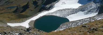
Glacier retreat is one of the most visible consequences of recent climate warming. Glacier retreat can result in the formation of glacial lakes, as already observed at various glaciers in the European Alps and other mountain areas in the world. FutureLakes analyzes the formation and the development of future glacial lakes in Austria and thus, supports essential adaptation strategies to high-alpine landscape change driven by glacier retreat.
more details ...
PROJECT CirqueMonHT
Glacierized cirques are defining high-alpine landscape elements which react sensitively to climatic changes. Within the ‘Arge Alp’-funded project CirqueMonHT we at GEORESEARCH, together with our partners, are establishing a monitoring system in the Ödenwinkelkar (Stubachtal Salzburg) aiming at the long-term observation of changes relevant to rock stability.
more details ...
PROJECT Tren a las Nubes

Since March 2017 we are working, funded by Austria Wirtschaftsservice Gesellschaft mbHand together with national and Argentinian partners, on our newest venture: Tren a las Nubes: Development potentials of an extreme mountain railway. The aim of the project is to define the chances and risks of the further development of the rail-bound freight transport along this railway connection between Argentina and Chile by using an interdisciplinary research approach. Natural hazards in this mountainous region may cause relevant costs in respect to maintenance and operation. GEORESEARCH is developing an innovative method based on cutting-edge satellite and drone technologies to detect natural hazard “hot spots”.
more details ...
PROJECT KaWaMon
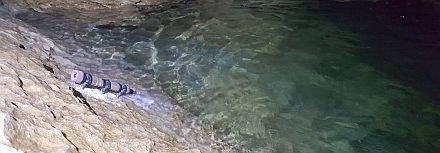
The hydrogeological properties of karst mountain areas have severe impacts on the water supply of adjacent settlement areas and can be used as indicators of imminent high water or dry periods. The long-term monitoring project KaWaMon (Karst Water Monitoring) comprises the continuous supervision of karst water occurrence in the Northern Calcareous Alps (i.a. Untersberg, Hagengebirge, Tennengebirge, Leoganger Steinberge) and the Hohe Tauern (Kitzsteinhorn). The collected data is consequently used to analyze, among other things, the drainage behavior and to gain information on the storage capability of the mountains.
PROJECT HydroFault
Interactions between hydrogeological, structural and geomorphic processes in fault zones are of severe importance for geological engineering and water management concerns. Building on research data collected at the fault zone of the Torrener-Joch (federal states Salzburg, AT & Bavaria, DE), the project HydroFault aims to quantify and analyze, under a holistic and interdisciplinary approach, the hydrology of fault zones and its correlation with structural geological and geomorphological processes.
PROJECT GroWaT
Groundwater recharge and the the flow dynamics in aquifers are sensitive to climate change and shifts in the settlement structure. Sustainable groundwater management requires the identification of long-term changes in order to enable appropriate mitigation measures. The project GroWaT (GroundWater Trends) investigates in the county Rif in the state of Salzburg the climatic, hydrogeological and anthropogenic effects on aquifers. Developing a set of modeling scenarios, diverse influencing factors are tested on their sensitivity and quantified regarding their predicted development in the future.
PROJECT Ingelsberg

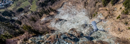
Due to its steepness, unfavorable stratigraphy, and immediate proximity to the residential and commercial area of Bad Hofgastein, the Ingelsberg represents one of the most relevant natural hazards in the entire province of Salzburg. Since 2020, GEORESEARCH is monitoring local mass movement activity on behalf of the municipality of Bad Hofgastein through a comprehensive monitoring based on UAV photogrammetry.
more details ...
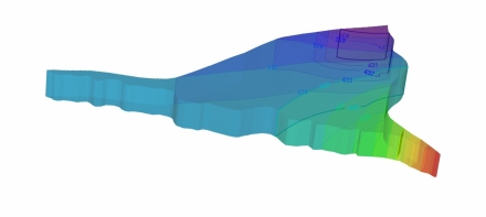
PROJECT Reservoir

Using InSAR, horizontal and vertical (east/west) displacements of measurement points can be recorded from space with an accuracy of ± 1-2 mm. The data is recorded regularly and fully automated by state-of-the-art SAR satellites. The Großarler Bergbahnen Ges. mbH & Co KG want to use this technology to improve local reservoir monitoring. The main goals of the project are long-term improvements in reservoir monitoring, a better understanding of the complexity of slope movement patterns and an improved level of site safety for the authorities.
more details ...
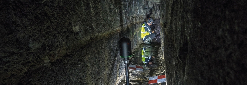
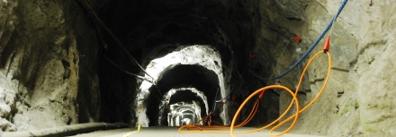
PROJECT UAS Underground

Thousands of underground structures were built by miners during the course of centuries and in modern times. Many of these sites are little known and practically impossible to be inspected by humans for various reasons. The Goal of UAS Underground is to develop a service based on UAS for inspections and 3D-modelling of such inaccessible underground structures.
more details ...
PROJECT AlpSenseRely

AlpSenseRely is a three-year reliability and potential study in four alpine regions (Bavaria, Tyrol, Salzburg, South Tyrol). It investigates high-availability remote sensing systems for early-warning of natural hazards in particularly climate-sensitive alpine regions. Due to its preventive character AlpSenseBech contributes significantly not only towards risk reduction, but also towards cost reduction of climate change related natural hazards. AlpSenseRely aims at anticipation and real-time warning of critical objects and processes in the impact environment of infrastructure. The three-year AlpSenseRely study systematically evaluates the scientific/applied reliability of early warning systems.
more details ...
PROJECT DefDrone_3D

Unmanned Aerial System (UAS, drones) have evolved rapidly for numerous areas of application in recent years. Particularly the use of latest sensor techniques open up intriguing possibilities in the field of deformation analysis. The aim of DefDrone3D is to develop a drone-based monitoring system to semiautomatically detect and analyse deformations.
more details ...
PROJECT AlpSenseBench

AlpSenseBench is a one-year benchmark pilot study in four alpine regions (Bavaria, Tyrol, Salzburg, South Tyrol). It investigates high-availability remote sensing systems for early-warning of natural hazards in particularly climate-sensitive alpine regions. Due to its preventive character AlpSenseBech contributes significantly not only towards risk reduction, but also towards cost reduction of climate change related natural hazards. AlpSenseBench aims at the anticipation of natural hazards and the real-time warning of critical objects around infrastructures.
more details ...
PROJECT P-SWARM

P-SWARM is a project aimed at generating photogrammetric data more efficiently by employing multiple drones flying in swarm mode instead of just one. We are currently developing a swarm box, comprising five UASs, for a smart and fast swarm data generating process. It allows for three different acquisition modes and real swarm communication and is adjusted to a DEM in order to ensure a precise flight, even in high alpine and other challenging environments.
more details ...
PROJECT SeisRockHT
SeisRockHT detects and analyzes seismic signals caused by high-alpine rockfall. For this purpose, seismic monitoring networks, designed for continuous, all year operation, are installed at the Sonnblick and at the Open Air Lab Kitzsteinhorn. At both sites, seismic monitoring is integrated into long-term monitoring infrastructure that delivers valuable complementary data.
PROJECT MoistureMonERT
Changing water contents of ground moraines and till significantly affect their mechanical properties and stability. Data on pore water changes are therefore of particular importance to tunneling projects and engineering geology. The main goal of MoistureMonERT is the development of a 2D ERT monitoring (Electrical Resistivity Tomography) for pore water that goes beyond 1D spot measurements.
PROJECT BIM in tunneling
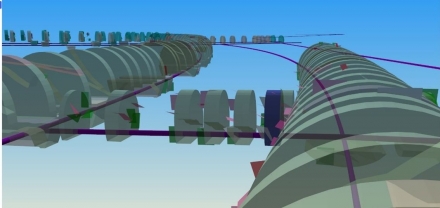
The prototypical character of tunnelling projects, specific software tools, individual data structures and a certain traditionalism within the companies involved impede the digital transformation process and pose major challenges to the introduction of the BIM (Building Information Modelling) methodology. The project "Interdisciplinary BIM-based planning, construction and operational process management in tunnelling" was commissioned by the Austrian Association of Construction Engineers (ÖBV) and aims at keeping data on the entire life cycle of an underground construction project within a single digital model.
more details ....
PROJECT HBLZ

The design of a high-alpine railway logistics centre represents a significant challenge. Especially when the project area is located in one of the world’s most remote regions – the Puna de Atacama, Argentina, at 4,000 m above sea level. The “Tren a las Nubes” (Train into the clouds) currently is the only active railway line across the Andes. Planned expansion of mining activities along the track will not only increase pressure on the existing railway but will also require infrastructure expansion. Based on the targeted use of innovative methods, holistic solutions will be generated – Building Information Modelling (BIM) will play a key role during this process.
more details ...
PROJECT BIMunderground
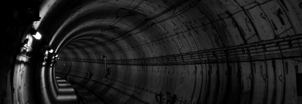
The integrative tool of Building Information Modeling (BIM) is already widely used in structural engineering in order to optimize planning, construction and operation. BIM data structures used for such applications, are not yet adequately adapted to infrastructure requirements. The overall aim of BIMunderground is thus, to adapt and optimize BIM for underground construction. Here, tunnel construction represents a particularly interesting challenge as not only tunnel elements but also geoelogical properties and resultant parameters have to be integrated into the model.