GEORESEARCH I NEWS
Publications, newspaper articles, TV reports, project kick-offs, conferences, technologies and a whole lot more. Stay up-to-date with the latest news from GEORESEARCH, all in one place and in chronological order.
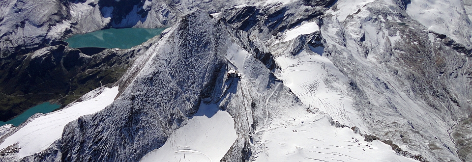
VAO Network

With the Open-Air Lab Kitzsteinhorn, GEORESEARCH was admitted as one of three new members in the network at the tenth Board Meeting of the Virtual Alpine Observatory (VAO) on March 19, 2024, in Innsbruck. Since its establishment in 2012, the VAO has brought together alpine research stations in 12 countries, facilitating cross-border, interdisciplinary collaboration to investigate scientific questions in the fields of Atmosphere, Biosphere, Hydrosphere, and Cryosphere systems, as well as the impacts of environmental influences on health. GEORESEARCH is proud to be part of the VAO network and looks forward to contributing a new versatile research site with the Open-Air Lab Kitzsteinhorn.
more details ...
ORF Topos Article

This recent ORF Topos article (published last Saturday) prominently cites our long-term research on permafrost degradation and rockfall activity in the Stubach valley and describes how human activity during the current geological era – the Anthropocene – is altering the face of the Earth.
more details ...
OPENING Research Campus Schloss Urstein

The "Research Campus Schloss Urstein" (RCSU) is launched! The RCSU stands for openness to new ideas, systemic thinking, interdisciplinarity and sustainability. These values are crucial to address future challenges and to further strengthen Salzburg as a research and business location. As part of the research WG, we contribute our expertise in the areas of climate change adaptation and sustainability. Together we are shaping a better future! Details can be found under the following link.
more details ...
TV DOCUMENTARY Bergwelten

The most recent episode of Bergwelten (broadcasted on TV 03.04.2023) is all about the Kitzsteinhorn. The immediate vicinity of nature conservation (National Park Hohe Tauern), hydropower use (Kaprun reservoirs), and tourism (Gletscherbahnen Kaprun) make the Kitzsteinhorn one of the most diverse mountains in the entire Alps. Click the link below to access the 46-minute documentary, including exciting insights into our research activities at the Open-Air-Lab Kitzsteinhorn.
more details ...
PROJECT Ingelsberg

Due to its steepness, unfavorable stratigraphy, and immediate proximity to the residential and commercial area of Bad Hofgastein, the Ingelsberg represents one of the most relevant natural hazards in the entire province of Salzburg. Since 2020, GEORESEARCH is monitoring local mass movement activity on behalf of the municipality of Bad Hofgastein through a comprehensive monitoring based on UAV photogrammetry.
more details ...
PROJECT HydroSAR

Our team at GEORESEARCH is proud to announce the launch of our newest project, HydroSAR. Together with our partners from the Government of Salzburg, Salzburg AG and the Technical University of Graz, we are working to assess the impacts of climate change on groundwater variability. HydroSAR aims to do just that by utilizing the power of satellite-based radar interferometry (InSAR) to measure groundwater-induced uplift/subsidence with millimeter accuracy.
more details ...
Publication Journal of Torrent, Avalanche, Landslide and Rock Fall Engineering

Our recent publication in the Journal of Torrent, Avalanche, Landslide and Rock Fall Engineering addresses the potential of satellite-based detection of ground motion for monitoring torrent catchments and protective structures. With advances in satellite missions and analysis techniques, satellite-based radar interferometry (SB-InSAR) can now detect ground motion with millimeter accuracy. It is a valuable tool for natural hazard analysis, especially in light of the expected increase in alpine natural hazards due to climate change.
more details ...
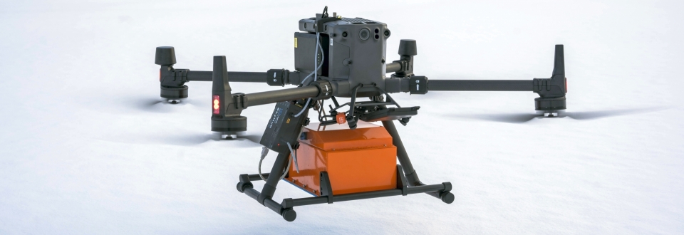
PROJECT STRATIFY

Experienced ski tourers know it well: Hazardous slab avalanches are caused by weak layers within the snowpack. Identifying these layers (before an avalanche is triggered) is key for safety considerations and is the focus of our new FFG project STRATIFY. The project is carried out by GEORESEARCH and LO.LA from Tyrol who will implement ground-penetrating radar mounted on UAVs for safe and precise air-borne snowpack characterization.
more details ...
Climate Change Adaptation in Ski Areas

How scientific guidance can help operators of ski areas adapt to climate change (and why high-alpine tourist areas represent ideal research partners). A new article in 'Der Standard' on our research activities at the Open-Air-Lab Kitzsteinhorn.
more details...
Webcam Sattelkar Landslide

Since July 2022 we are using a high-resolution webcam to monitor the extensive Sattelkar landslide at the Obersulzbach valley. The acquired photos and videos are updated daily and allow the reconstruction of slide rates and single events. Follow the link below for direct access to our Sattelkar webcam.
more details...
Der Standard Forschung Spezial

Fresh newspaper article on our longterm monitoring activities at the Sattelkar (Obersulzbach valley, Salzburg). The article was published on 17.08.2022 in the science supplement (Forschung Spezial) of 'Der Standard'. Click below to learn more.
more details...
ORF Salzburg Heute

On 11.07.2022 the ORF news program 'Salzburg Heute' covered our research activities in the Hohe Tauern Range and addressed how recent climate warming increases debris flow and rockfall risks. The video clip is available via ORF TVthek until 18.07.2022, an ORF Online news article is posted under the following link.
more details ...
PODCAST Alpenrauschen

In the fourth episode of the 'Alpenrauschen' podcast we talk about natural hazards driven by climate change and we report on the impacts that recent glacier recession has on landscape diversity, tourism and life in the Alps (in German language). Many thanks go out to CIPRA Österreich and the Umweltdachverband for having us! Follow the link below and tune into the half-hour podcast.
more details ...
UAV Training

In cooperation with the ADTF (Austrian Drone Task Force) we are offering a brand new UAV training. In six course modules we introduce you to the world of drones and point cloud processing and equip you with everything you have to know to plan and execute your own UAV missions. Whether you are an absolute rookie seeking a drone license or whether you already have basic UAV experience: we will provide you with the right training. Participants based in Austria can use the FFG Digital Skills Check get up to 80 % of the course fees refunded.
PROJECT RockSAR

Large mass movements are often preceded by deformation in the millimeter range. Small-scale precursory deformation is extremely hard to identify and hence can only be studied at known, active slope failures. In the ARGE ALP project “RockSAR – Identification of millimetric rock slope deformation with InSAR” we are performing extensive InSAR analyses (Interferometric Synthetic Aperture Radar) to identify currently unknown, slow rock slope failures in the Eastern Alps.
more details ...
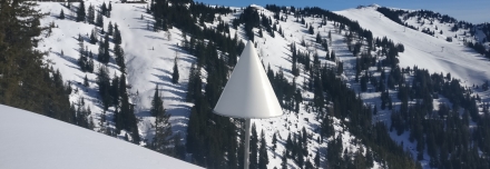
RADON Monitoring

Can radon detectors be used for rockfall monitoring and prediction? At the prominent Ingelsberg rockslide (Bad Hofgastein) we and our colleagues from IAF-Radioökologie GmbH (Dresden, Germany, www.iaf-dresden.de) and the Geological Survey of Salzburg are the first to investigate the applicability of radon measurements for early warning systems. As rock slope activity increases, new cracks and fissures appear through which the radioactive element radon can be exhaled. Already a few thousand radon atoms are sufficient to detect changes in radon concentration and slope movement rates.
We are very much looking forward to the first results and thank the municipality of Bad Hofgastein for the great support!
more details ...
BVLOS Flight

We raised our UAS competence to a whole new level! With immediate effect, our drone fleet is officially authorized to operate in the ‘Specific’ category. As one of only a few UAS operators in Austria we are now entitled to carry out BVLOS (Beyond Visual Line of Sight) flights. We performed the first such flight on Tuesday within an avalanche research project in the Niedere Tauern Range. The required skitour in bright sunshine did not bother us too much...
Many thanks to Dronesolut for supporting us at ConOps and Sora!
PUBLICATION Glacial Lakes in Austria

Glaciers in Austria and the entire Alps are shrinking at a record-setting pace, yet little is known about the exposed proglacial areas and the subglacial relief. In a brand new study we have now estimated the potential formation of future glacial lakes in Austria. We combined several ice thickness models to localize glacier bed overdeepenings (GBO) and found 42 locations where lake formation is highly likely after deglaciation. The full study is available at ESPL (Earth Surface Processes and Landforms).
more details ...
MEDIA Article Open-Air-Lab Kitzsteinhorn

High-alpine regions around the globe are particularly vulnerable to climate change. More than ten years ago we therefore initiated the ‘Open-Air-Lab Kitzsteinhorn’ which monitors the consequences of climate change and contributes to sustainable climate change adaptation measures in high-alpine regions. The ‘Salzburger Nachrichten’ have now published an overview article on our research activities at the Kitzsteinhorn which is linked below (registration required). A very warm thank you goes out to the Gletscherbahnen Kaprun Kaprun for the fantastic collaboration over the last ten years.
more details ...
PUBLICATION Sattelkar Landslide

How can UAV photogrammetry and satellite imagery help improve our understanding of large mass movements? Together with our colleagues from the TU Munich we studied deformation patterns at the complex Sattelkar landslide (Nationalpark Hohe Tauern) to investigate the chances and limits of state-of-the-art optical remote sensing methods. Results have now been published in “Natural Hazards and Earth System Sciences” and show the growing potential of UAV and satellite imagery for the early detection and early warning of hazardous landslides and rockfalls.
more details ...
PUBLICATION Factsheet Permafrost

Around half of all global soil carbon is stored in permafrost regions and reacts sensitively to future climate warming. The Food and Agriculture Organisation of the United Nations (FAO) has now presented a report on management practices for the recarbonization of global soils. As part of an international research team led by the Alfred Wegener Institute Helmholtz centre for polar and marine research, GEORESEARCH is proud to contribute to this highly relevant report with a factsheet on permafrost soils (Volume 2, Section 9).
more details ...
MEMBERSHIP ADTV

Proud to be a part! Last month GEORESEARCH has become member of the Austrian Drone Task Force (ADTF). The ADTF is the Austrian professional association for all unmanned aviation. The ADTF is committed to the development, design, manufacture and safe and effective operation of Unmanned Aircraft Systems (in the following named "UAS" or "UAV's"). We will gladly provide our expertise and we look forward to this new and exciting collaboration.
more details ...
PROJECT Reservoir
Using InSAR, horizontal and vertical (east/west) displacements of measurement points can be recorded from space with an accuracy of ± 1-2 mm. The data is recorded regularly and fully automated by state-of-the-art SAR satellites. The Großarler Bergbahnen Ges. mbH & Co KG want to use this technology to improve local reservoir monitoring. The main goals of the project are long-term improvements in reservoir monitoring, a better understanding of the complexity of slope movement patterns and an improved level of site safety for the authorities.
more details ...
PUBLICATION InSAR Data available at SAGIS
Satellite-based radar data analyzed within our Interreg project “SedInOut” is now available online at SAGIS (Salzburger Geographisches Informationssystem). The published datasets contain millions of measured points that reveal millimeter-scale ground motion. Follow the link below to learn more.
more details ...
CONFERENCE Klimatag

Climate change represents one of the greatest and most transcending challenges facing our world today. The annually held ‘Klimatag’ is Austria’s biggest scientific conference on climate change and provides a broad platform for dialogue among scientists, public officials, industry representatives and various other stakeholders. The Klimatag is hosted by the CCCA (Climate Change Centre Austria) and due to the Corona pandemic was held as a large online conference this week. GEORESEARCH was prominently featured at the Klimatag – our conference talk (‘Glacier retreat enhances high-alpine rockfall activity) is available here (German only).
more details ...
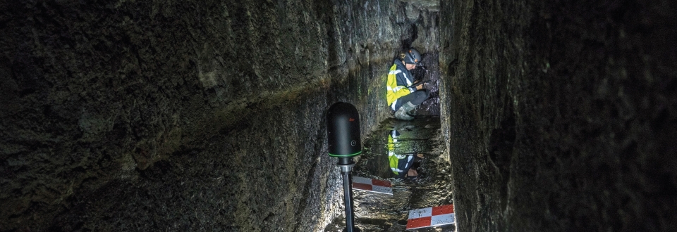
PROJECT UAS Underground

Thousands of underground structures were built by miners during the course of centuries and in modern times. Many of these sites are little known and practically impossible to be inspected by humans for various reasons. The Goal of UAS Underground is to develop a service based on UAS for inspections and 3D-modelling of such inaccessible underground structures.
more details ...
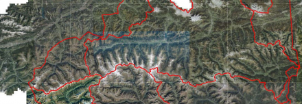
PROJECT AlpSenseRely

AlpSenseRely is a three-year reliability and potential study in four alpine regions (Bavaria, Tyrol, Salzburg, South Tyrol). It investigates high-availability remote sensing systems for early-warning of natural hazards in particularly climate-sensitive alpine regions. Due to its preventive character AlpSenseBech contributes significantly not only towards risk reduction, but also towards cost reduction of climate change related natural hazards. Of special interest is the anticipation and real-time warning of critical objects and processes in the impact environment of infrastructure.
more details ...
FIELDWORK Crackmeter Installation
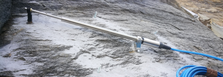
Open-Air-Lab Kitzsteinhorn: Rockfall monitoring expanded! Rockfall events are often preceded by minimal surface displacement (joint aperture changes), which can be detected with high-precision crackmeters. Within the RIDGES project we recently installed four brand-new crackmeters in the north-face of the Kitzsteinhorn and hope to gain new insights into the kinematics of high-alpine rockwalls, which are heavily affected by atmospheric warming and glacier retreat.
PUBLICATION Earth Surface Dynamics I
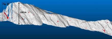
In the first of two companion papers we investigated the relationship between dramatic recent glacier retreat and high-alpine rockfall occurrence. The rockfall dataset analyzed is the most extensive of its kind worldwide and revealed a significant pattern: Rockwalls that became deglaciated in the last years and decades are particularly prone to rockfall.
Check out the latest issue of the internationally renowned magazine "Earth Surface Dynamics" and read the full paper which has been selected as "Highlight Article" by the journal editors.
more details ...
PUBLICATION Earth Surface Dynamics II
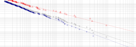
In the second of two companion papers we analyzed rockfall volume and frequency around a retreating glacier in the Hohe Tauern Range (Austria) based on a six-year laserscan-monitoring. In recently deglaciated rockwall sections rockfall frequency increased by 60 % while rockfall volume increased by a staggering 800 %. More details and analyses are available in the linked full paper.
more details ...
MEDIA TV feature on randkluft research

How does current glacier retreat affect rock stability and the occurrence of rockfall events? No place is possibly better-suited to investigate this question than the randkluft, i.e. the void between the glacier and the adjacent rockwall. A recent TV feature (PM Wissen, Servus TV, only in German) takes you on a short trip into the randkluft and provides some interesting insights into our high-alpine research activities (Project GlacierRocks).
more details ...
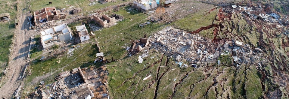
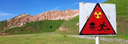
MEDIA Radioactive Waste in Kyrgyzstan

Radioactive waste and the legacies of uranium mining combined with massive landslides pose tremendous risks to vast areas of Kyrgyzstan and their inhabitants. Funded by EuropeAid, we developed a new landslide early warning system in direct collaboration with our partners - a recent ORF news article on our project is available here (only in German).
more details ...
MEDIA ORF news article Sattelkar

In high-alpine cirques, climate change-induced permafrost degradation and an increase in liquid precipitation are projected to promote the availability of fresh, unconsolidated sediments. The relevance of cirques as source areas of hazardous mass movements is therefore expected to grow significantly. Together with the Nationalpark Hohe Tauern we are currently running a long-term monitoring to better understand the causes and consequences. Recently the ORF (Austrian Broadcasting Corporation) covered our research activities at the Sattelkar (Obersulzbachtal, Salzburg) with a news article and a TV report (German only).
more details ...
PROJECT UPDATE SedInOut
In what ways does apparently stable terrain change over time? To answer this question we are performing innovative InSAR satellite data analyses capable of deciphering surface changes at millimeter accuracy.
In our new Interreg project “SedInOut” we have now started a large-scale investigation focusing on terrain surface changes in the provinces of Salzburg, Carinthia, Tyrol, Upper Austria, and South Tyrol. The initiated InSAR-based study is unique in Austria and covers around 19.000 km².
Together with our friends from TRE ALTAMIRA (Italy/Spain) we are currently analyzing about 5.000 GB of satellite data to reconstruct terrain surface changes over the last five years. Stay tuned for more details!
more details ...
PHD-PROJECT RIDGES

In April the three-year PhD project RIDGES was started at the University of Salzburg (funded by the Austrian Academy of Sciences). In the project PhD student Andreas Ewald will investigate connections between glacier retreat and rockfall activity in oversteepened cirque walls. GEORESEARCH will assist RIDGES by providing logistical and advisory support at the Open-Air-Lab Kitzsteinhorn.
more details ...
KONFERENZ EGU 2020

From 3-8 May 2020 the annual General Assembly of the European Geoscientific Union - EGU will be held FREE of admission fees and ONLINE for the first time. GEORESEARCH will participate with five contributions covering automatic landslide detection based on multispectral data, rockfall in deglaciating headwalls and many other exciting topics!
PROJECT SedInOut

Landslides and debris flows are frequently preceded by continuous annual deformation in the centimeter range. However, due to the problematic detectability of small-scale slope movements little is known about their geographical distribution and their potential in indicating the spontaneous – and sometimes catastrophic – occurrence of natural hazards. The project ‘SedInOut’ targets the development of a methodology to detect and analyze small-scale slope movements in order to systematically assess mass movement risks on alpine slopes.
more details ...
MEMBERSHIP CCCA

Proud to be a part! Last month GEORESEARCH has become a full member of the renowned Climate Change Centre Austria (CCCA). The CCCA supports science transfer and education, advises politics and society – and therefore plays a key role in strengthening Austrian climate research. We will gladly provide our expertise and we look forward to this new and exciting collaboration.
more details ...
COOPERATION TRE ALTAMIRA

GEORESEARCH visited TRE ALTAMIRA in Barcelona for discussing future joint InSAR operations in the fields of civil engineering, natural hazards, water/urban management as well as mining. Many thanks for the great hospitality and fruitful discussions!